

Egypt
Agriculture Drones In Africa
Drones & Data for Precision Agriculture in Egypt

Best Agriculture Farming Drones for Crop Spraying in Egypt
#trithirobotics #3thi #Droneer #india #1st #agriculture #precision #spraying #drones #best #farming #startup #uav #agriculturetechnology #sprayingdrone #farminglife #agricultureproducts #awards #worldwide #indian #unitednations #FeedMoreForLess
#Droneer a #pioneer in #agriculture #drones now in #Egypt #Farming #Drones & #Crop #Spraying #Drones in #Africa #Pesticides Drones #Insecticide Drones #Fertiliser Drones in #Egypt #Granular Spreader Drones, #Heavy Lift Large Drones in #Egypt #Precise Agriculture Sensors, #Multispectral Sensors Drones, #Hyperspectral Sensors for UAVs, #Lidar Payloads in Egypt.
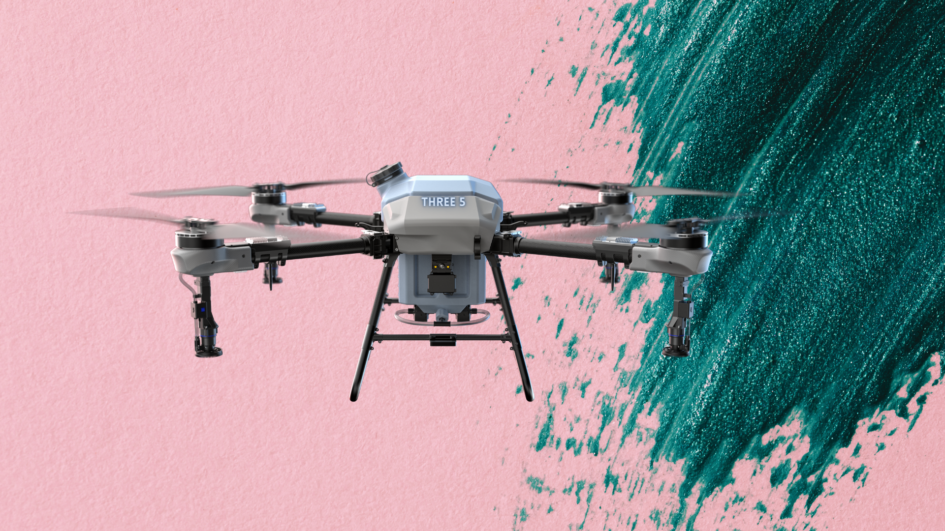
Droneer Three5
Enterprise Grade, 35 Litre Crop spraying drone that comes with all advanced avionics you need in field for large hectare coverage.
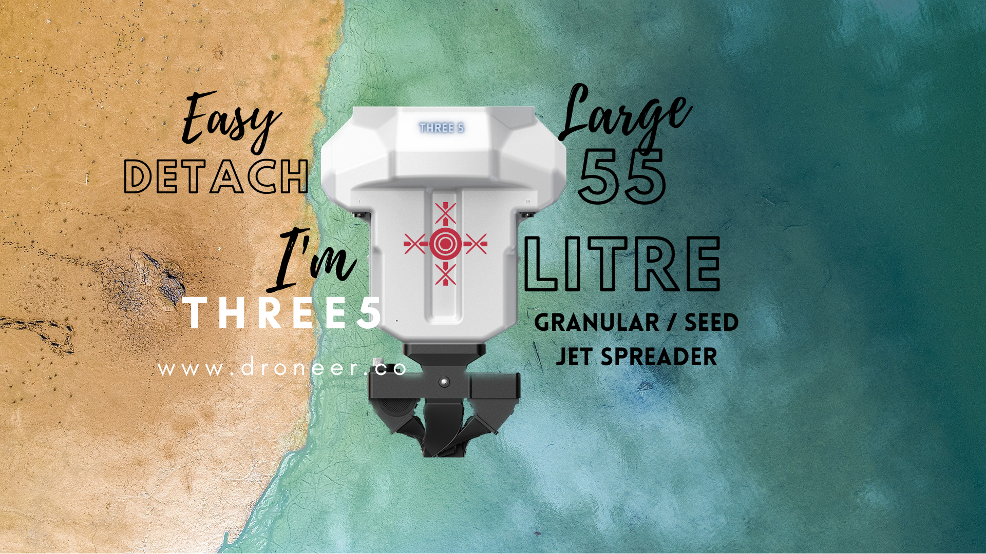
35 litre liquid / 55 litre granular spread per 2.5 hectare calibration, single flight covers 2.2 hectares each flight.
Single battery can support 4.5 hectares / 70 litre spray.
With default 2 batteries can provide 9 hectares / 140 litre spray before recharge.
650 recharge cycle of single battery can provide 2860 hectares bringing per acre fly cost under 30¢ Lowest in Industry.
Charging
Store / Charge – Under 13 Mins.
Flight Controller
Enterprise grade full backend access with agri spray specific
Patented ‘∠‘ 45° calibration mechanism
Fly Time
Unmatched 4.5 hectares per battery charge.
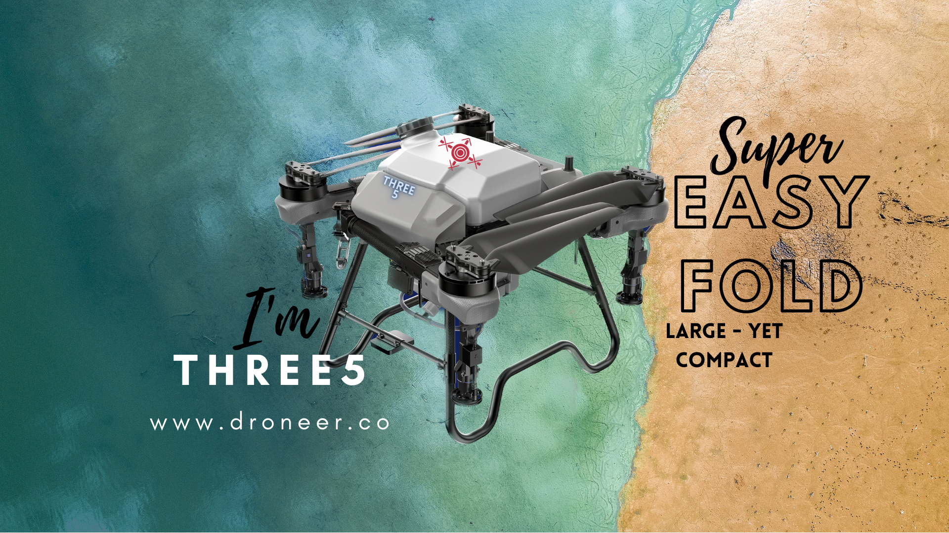
Design & Architecture
Only quadcopter design with 40-55 litre in Agri Spraying Category.
Scalable design that lifts from 30 litre upto 55 litre carry capacity.
Droneer One5
Enterprise Grade 15.5 litre crop spraying drone that comes with all advanced avionics you need in field.
15.5 litre / hectare calibration of chemical, single flight covers 1 hectares / 2.5 acres.
Single battery can support 2 hectares / 31 litre spray.
With default 2 batteries can provide 4 hectares / 62 litre spray before charge.
650 recharge cycle can provide 1300 hectares / 3250 acres bringing per acre fly cost under 50 Rs.
Charging
Store / Charge – Under 15 Mins.
Flight Controller
Enterprise grade full backend access with agri spray specific
Patented ‘∠‘ 45° calibration mechanism
Fly Time
Unmatched 2 hectares per charge.
Design & Architecture
Only quadcopter design in Agri Spraying Medium Category.
Scalable design that lifts from 16 litre upto 45 litre carry capacity.

Future Of Agri Drones are HERE
Droneer series is made for Large Farms / Food Producers whose aim to cover 50+ Hectares in 5-6 hours each day.
Drone spray efficacy is best achieved when sprayed before 10 AM, between 4.30 to 6.30 PM. Droneer Three5 series made keeping the large Growers & Farms who can seamlessly manage farms @ ease.
Commanding Features
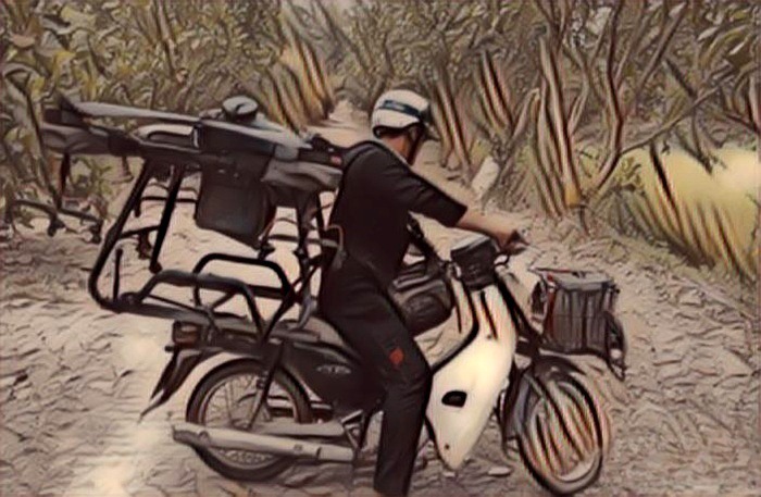
Easy to Carry
On Motorcycle / 3 Wheeler, Compact foldable design.
Obstacles & Terrains
From 40 to 1 Meter 5 Beam Sensor Integrated front & Rear & Bottom.
Integrated Remote Controller
With 5.5 Inch bright screen, 1SPRY App Integrated rage of upto 10 KM.
Functional Fly
Dosage, Row, Height, Speed setup for 30+ Types of crops.
Dual Purpose FPV & LED
FPV camera & LED flood lights can face down for view beneath & Landing.
Countless Personalisation
Name Embossed, Choice of Color, Apple AirTag Inbuilt & Many more.
Three5 Specs:
MTOW
92 Kg
Solid State Lithium Polymer
14S 30Ah with Molex Plug
Fast Charger
5C Fast Balance Charge & 8 DC Fast Discharge.
Remote Controller
WPC ETA Certified 10 km radius capable with 5.5 inch high bright screen supporting Dual FPV mode.
1SPRY App
1SPRY – Enterprise grade, backend cloud access with fleet management software integrated with Flight Controller.
Sought After Functions
-
Breakpoint Memory with return to home & resume to break point.
-
Nozzle calibration with dosage & pump pressure setups.
-
Dual flowmeter with accurate brushless disbursement.
-
Auto Set Crop Height.
-
Auto Set Row Width.
-
Auto Set Obstacle Avoidance Warning.
-
Auto Set Terrain Sensing Warning.
-
A & B Route Planing.
-
Height Auto Set at 30 Meter
-
Customisable RTH / Return Path Algorithms.
One5 Specs:
MTOW
42 Kg
Solid State Lithium Polymer
14S 20Ah with Molex Plug
Fast Charger
Supports 4C Fast Balance Charge & 8C discharge
Remote Controller
WPC ETA Certified 5 km radius capable with 5.5 inch high bright screen supporting Dual FPV mode.
Industry’s Best Functions
-
Breakpoint Memory with return to home & resume to break point.
-
Nozzle calibration with dosage & pump pressure setups.
-
Dual flowmeter with accurate brushless disbursement.
-
Auto Set Crop Height.
-
Auto Set Row Width.
-
Auto Set Obstacle Avoidance Warning.
-
Auto Set Terrain Sensing Warning.
-
A & B Route Planing.
-
Height Auto Set at 30 Meter
-
Customisable RTH / Return Path Algorithms.
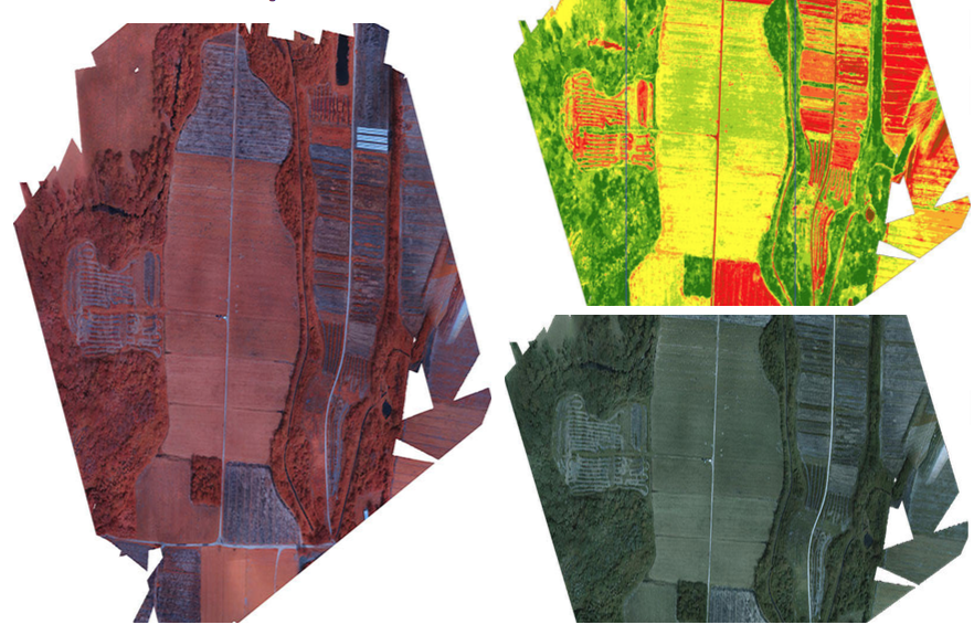
Agriculture Industry’s Best Crop Health Monitoring Sensor Drones

Scientifically Accepted - Industry Admired & Farming Game Changer
Droneer provides finest & industry best crop data analysis sensors drones.
Our 2023 models Rededge P, Altum PT are some of world’s best sensors available to use on any of the flying platform to capture the farm & crop images.
Post capture, one can transfer images to computer for image processing and generate 30 types of indices for analysis & prescriptions thus bringing precision agriculture to your farm.
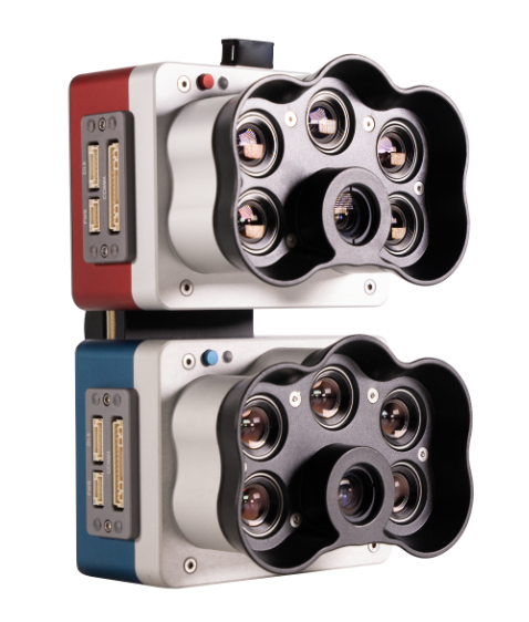
2023 Altum PT for Precision Crop Data Analysis
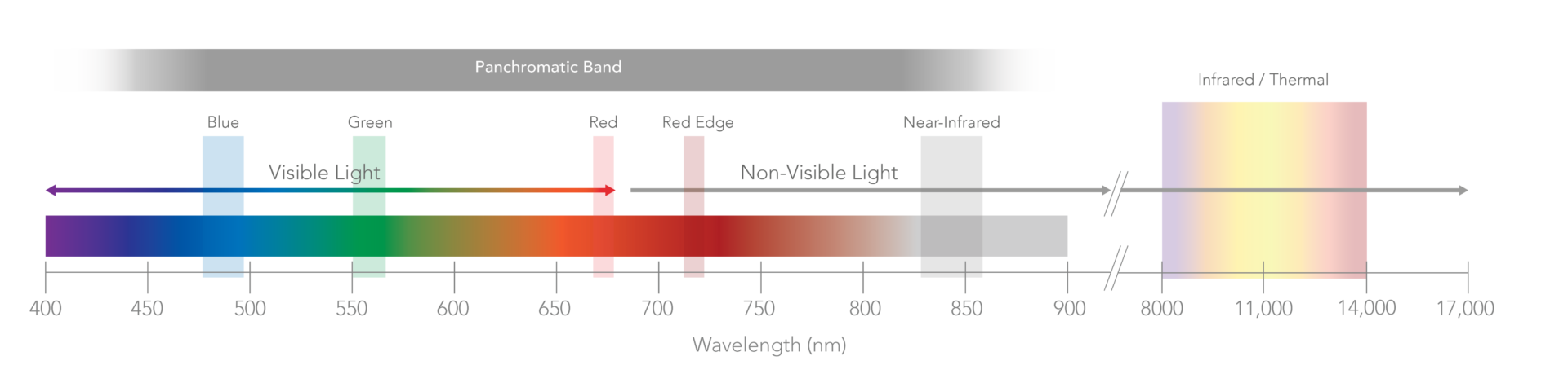
The Droneer’s Altum-PT captures synchronized multispectral, thermal, and panchromatic data for pixel-aligned outputs at incredibly high resolutions. The capture of these bands happens simultaneously, eliminating the need for data alignment in post-processing.
Core Capabilities
Work type
Crop Health Monitoring & Data Process & Analysis
Major Outputs
NDRE, RGB, CIR, NDVI, DSM, Chlorophyll Map Etc.
Data Use Cases
30 Type of Indices
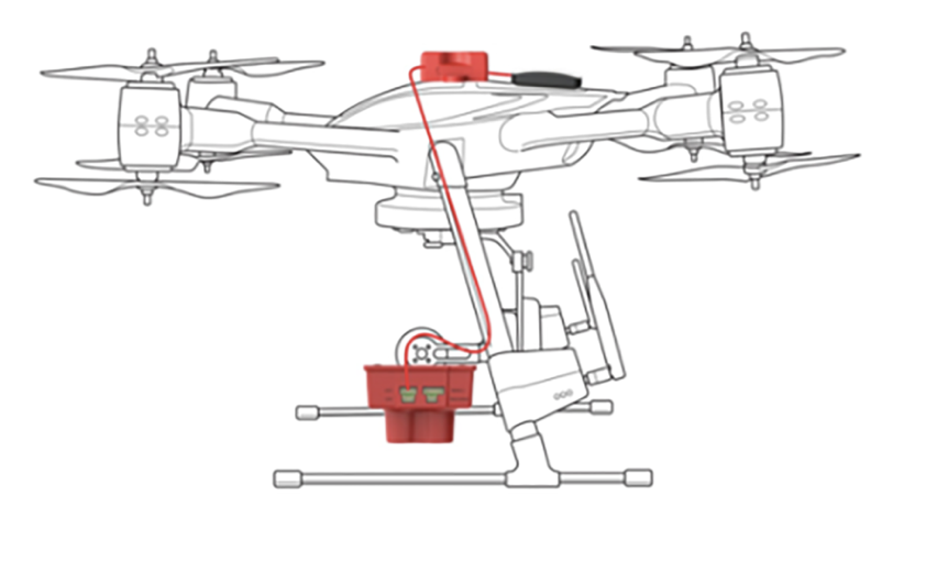
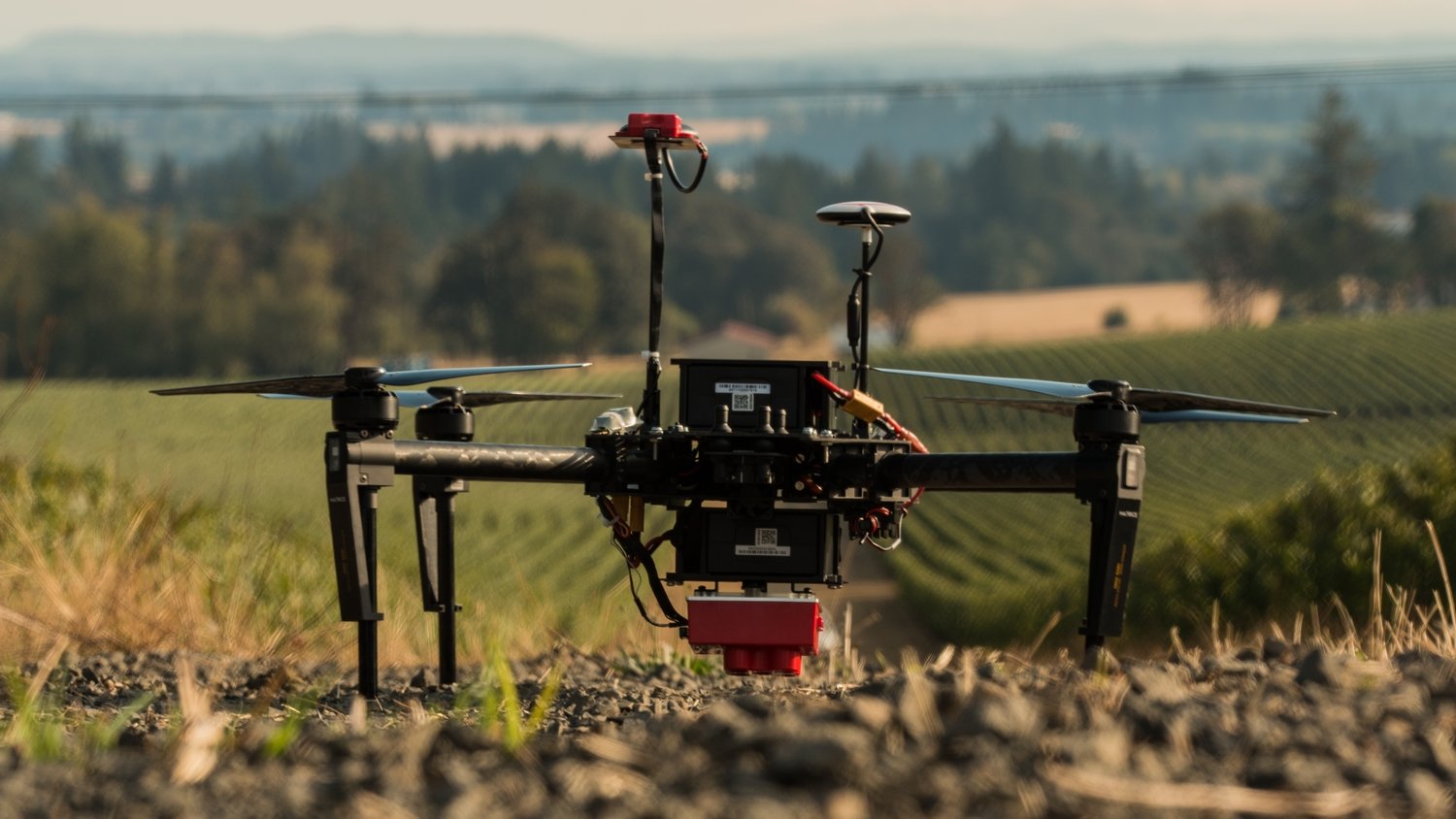
Equipment Setup
UAV integrated with Multispectral Camera.
THE MOST ACCURATE RESULTS AT LEAF-LEVEL RESOLUTIONS
CALIBRATED MULTISPECTRAL IMAGERY
CRP 2 A new compact version of our Calibrated Reflectance Panel. Same functionality, now in a smaller size and easier to carry!
**Note: Each camera kit comes with the radiometric calibration tools you need to enable comparison over time.
DLS 2 Our next-generation light sensor, with cutting-edge technology for irradiance and sun angle measurements. It provides more accurate, reliable data, greatly reduces the need for post-processing, and substantially improves radiometric accuracy. With the integrated GPS, setup with any aircraft is simple.
Welcome to the World Of Precision Data for Farming
KEY FEATURES
INCREASED STORAGE
New professional removable storage standard in CFexpress, enabling over two captures per second, immediate turnaround time between flights by swapping cards, and super-fast card-to-computer upload speeds for more efficient data management.
TWICE THE SPATIAL RESOLUTION OF THE PREVIOUS ALTUM
Altum-PT features an ultra-high resolution panchromatic sensor which allows for “pan-sharpening” the multispectral imagery, ultimately increasing the spatial resolution of the multispectral data: 1.2 cm (0.47in) pan-sharpened ground resolution when flying at 60m (200ft).
UPGRADED THERMAL SENSOR
Altum-PT features a built-in 320 x 256 FLIR Boson® that enables thermal maps at twice the ground resolution of Altum – 17cm from 60m flight altitude.

Find Early – Act Now – Save Crop
KEY FEATURES
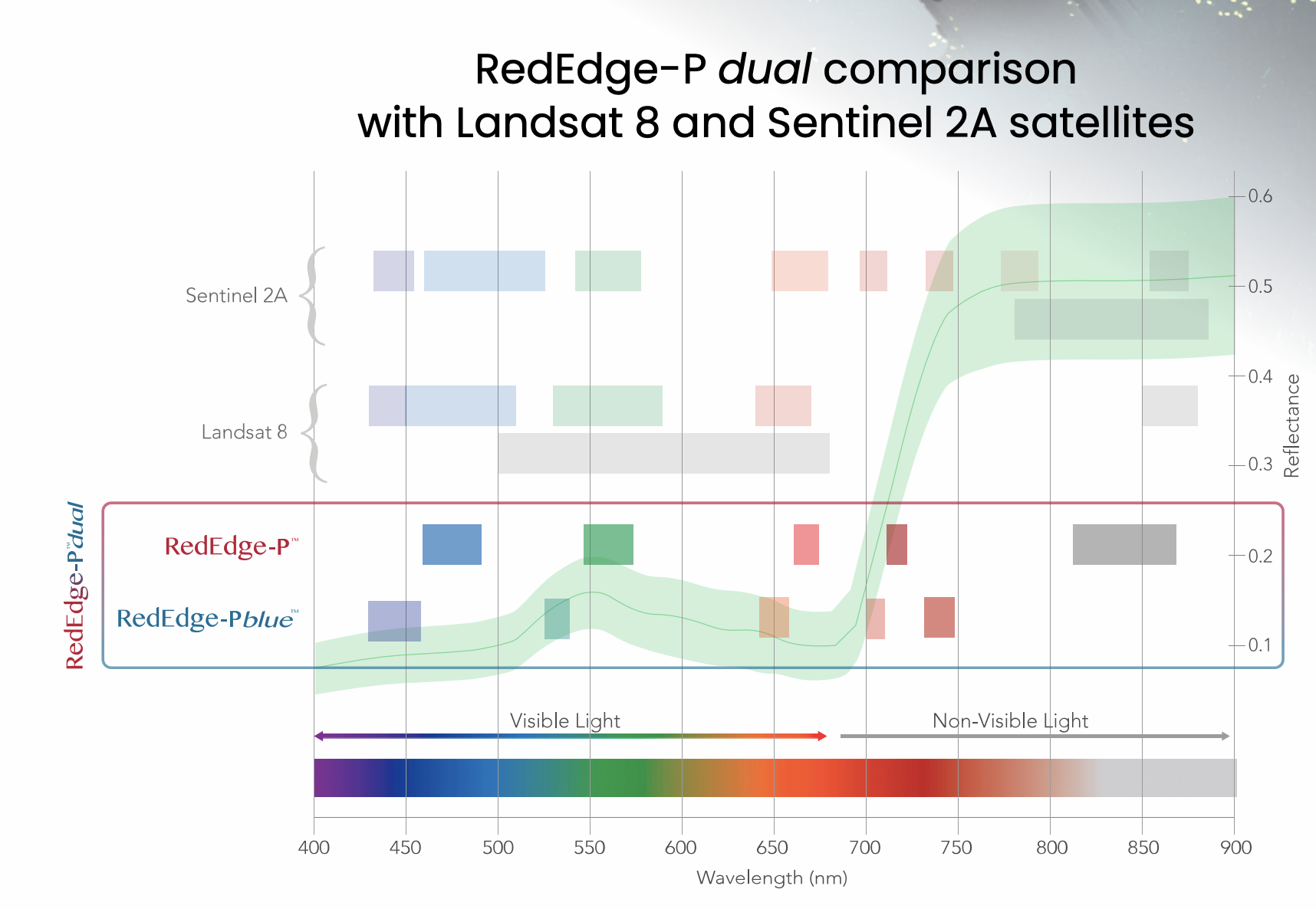
CALIBRATED NARROW BANDS
Five narrow high resolution (8 cm/pixel at 400 ft) spectral bands captured during one flight. Calibrated for precise, repeatable measurements.
RUGGED AND DURABLE
New aluminum body for better durability and performance in higher temperatures. Global shutter imagers – no gimbal required and no moving parts.
FULL FLEXIBILITY
Compact size allows for integration with a wide variety of drones. Full access to raw data; outputs can be generated using a wide variety of processing and analysis platforms.
INCREASED DATA ACCURACY
AND REPEATABILITY
You know the benefits of forecasting and data precision. We have a focus on accuracy and repeatability in our data and analysis, so that you can trust the data we help you gather. Take a look at multiple case studies that can show you how we do it and how it can help your business.
Crop Data Output
CAPTURE – PROCESS – ANALYSE
| PLANT COUNTING | Plant counting algorithms require high-resolution imagery. RedEdge-P combines a Panchromatic lens with 5-high-res multispectral lenses enabling high-res RGB and multispectral outputs, allowing plant count even at early growth stages. |
| PHENOTYPING | Manually measuring plant characteristics is time-consuming. RedEdge-P band combination enables high-resolution multispectral outputs, allowing the detection of variability at the leaf level. |
| PLANT HEALTH MAPPING | RedEdge-P’s high-resolution multispectral outputs allow the generation of indices and composites to see individual chlorophyll levels in the plants and compare over time. |
| FERTILIZER MANAGEMENT | RedEdge-P’s high-res and accurate outputs allow easy identification of areas low in nutrients and help monitor the effects of fertilizer applications throughout the season and determine if, when, and where a new application is needed. |
| DISEASE IDENTIFICATION | RedEdge–P captures a critical part of the light spectrum for studying plants (712–722 nm), called the red edge band. It is in this section of the spectrum that the first signs of stress start to show. Using analytics generated with the red edge band, it is possible to identify disease sooner and act faster to stop the spread. |
| SPECIES DIFFERENTIATION | Some differences among species may not be visible to the naked eye. High-res multispectral data allows for species differentiation, weeds included, by highlighting characteristics such as chlorophyll content, vigor, and leaf size. |
| ADVANCED CROP SCOUTING | High-res multispectral and RGB imagery provides advanced field scouting capabilities. In one flight, it is possible to collect accurate and geotagged information of a problem, making it easy to assess the situation and determine the appropriate intervention. |
| HIGH-RES 3D Point Clouds | RedEdge-P’s 5.1-Megapixel panchromatic band provides over twice the ground resolution of the industry-standard RedEdge-MX, resulting in 3D point clouds with up to 4 times the point density. |
Love to See it in Action?View it